presents
|
presents
|
What is ImageMapConverter?ImageMapConverter is an Apple Macintosh application to convert ImageMap files, used in World Wide Web documents, to and from different formats.It is very useful for converting old Server Side Imagemaps into the new Client Side Imagemap format which is incorporated in the HTML-code without the need to recreate the hotspot-areas. To insure compatibility with older browsers ImageMapConverter can also convert Client Side Imagemaps (Usemaps) into Server Side Imagemaps. Where do I get ImageMapConverter?ImageMapConverter is available through all Info-Mac sites. You can follow this link to the INFO-Mac Hyperarchives to find it.. Or this one to the AMUG sites in Arizona. Or finally, get it in Rotterdam, The Netherlands. The filesize is aproximately 680 K.If you pay the shareware fee you'll get info about updates, FAT and Powermac versions, and the URLs where you can download them.
What does ImageMapConverter require to run?ImageMapConverter should run on any Macintosh running System 7.x.x. It has been tested on a PowerMac 8100/100, PowerMac 7600, Performa 630 and a Quadra 700 with the following systems: System 7.1.1, System 7.1.2, System 7.5.1, and System 7.5.3.It requires at least 1500 K of free application memory although 4500 K is recommended. Special Features of ImageMapConverter:
More about ImagemapsImagemaps are basically clickable pictures. When the user clicks on the picture, he will be linked to different pages depending on where on the picture he clicked.There are two flavours of imagemaps: Server Side Imagemaps and Client Side Imagemaps.
Server Side Imagemaps
Client Side Imagemaps or Usemaps Conversion FormatsCurrently the following conversions are supported: NCSA to Usemap, CERN to Usemap, Usemap to NCSA and Usemap to CERN (Usemap is another name for Client Side Imagemap). If you want to convert a CERN imagemap to the NCSA-format (or vice-versa) you can do so in two steps: Convert the NCSA to Usemap and then convert this Usemap to CERN.The specifications of the different formatsNCSA:
CERN:
USEMAP
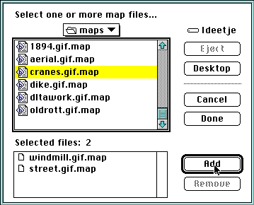
How does ImageMapConverter work?The usage of ImageMapconverter is fairly straightforward.Just click one of the Convert buttons: if you've pressed the Convert File(s) button you will see the following Dialog window:
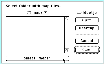
Go to the location on your harddisk where your mapfiles reside and select one or more mapfiles (or HTML files containing imagemaps) by pressing the add button or by double-clicking them. Then press"Done" and ImageMapConverter will start converting your files. If you've pressed the Convert Folder buttons you will see the following Dialog window:
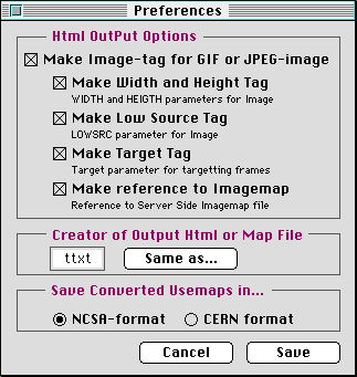
Go to the location on your harddisk where your mapfiles reside and select a folder with mapfiles in it. Then press "Select ..." and ImageMapConverter will start converting all mapfiles or HTML files it finds in that particular folder. If the folder contains textfiles which aren't mapfiles or HTML-mapfiles a requester will pop up stating that the file couldn't be processed. Setting the PreferencesIn the Preferences screen of ImageMapConverter you can set the following user configurable preferences:
HTML Output OptionsMake Image-tag for GIF or JPEG-image Here you can choose the Creator codes of the TEXT files that ImageMapConverter generates, so they will be automatically opened by your favourite HTML-editor when you double click them. To do this press the "Same as..."-button and select a file that has the desired creator code e.g. a file that is saved by that particular application. Select the format in which ImageMapConverter will export your converted Client Side Image Maps. This can be either NCSA or CERN. You have to consult your Internetprovider or system operator to find out what format they use on their webserver.
FilenamesImageMapconverter uses the following naming scheme for filenames:
PathsAlthough ImageMapconverter tries to be as intelligent as possible in resolving filenames and paths, its output files aren't perfect and you need to fine-tune them. You probably need to change the paths to your images from relative to absolute or vice versa. And since ImageMapconverter doesn't know the location of the CGI-script you use to process your Server Side Image Maps you'll have to add this path as well.How can I test ImageMapConverterThere are some mapfiles provided with this application to test it. They are in the "testmaps" folder. You can also test ImageMapconverter ability to process HTML files with this documentation file. And of course you can test it with you own mapfiles.Does ImageMapConverter correct my mapfiles?Unfortunately ImageMapConverter isn't an intelligent creature. If your mapfiles in one format won't work on the Internet, chances are high that the converted mapfiles won't work either. On top of that you probably need to add or adjust some pathnames, sizes and the like to make converted Imagemaps work.How much does ImageMapConverter cost?ImageMapConverter is shareware: if you like it and continue using it, you should pay for it.
The cost is $10 for a single-user license, $200 for a site license (unlimited use at a single site), and $1000 for a world-wide site license (unlimited use at as many sites as you need). All prices and options are shown in the 'Register ImageMapConverter' application. How do I pay for ImageMapConverter?To register, run the 'Register ImageMapConverter' application, included in this package (or contact me and I'll send it to you), to fill out the registration form. Once you've filled it out, you have 3 options for paying:1) Print it and send it, together with your payment, to Kagi at:
Kagi This address is also on the registration form that the 'Register ImageMapConverter' application prints. 2) E-Mail it by clicking "Copy" in the 'Register ImageMapConverter' application and pasting it into the body of your e-mail message to: sales@kagi.com 3) Fax the registration form to this number: +1 510 652-6589. If you have any questions, don't hesitate to contact me at mare@kagi.com. The payment options are shown in the 'Register ImageMapConverter' application. You can pay with cash (in many currencies), check, credit card (VISA, MasterCard, or AmEx), or various other forms of payment (check out the 'Register ImageMapConverter' application for other forms of payment).
ImageMapConverter has no protection scheme but when you pay, we will send you a serial number which you can enter into ImageMapConverter's register screen.
If you do not have an email address you should consider selecting the Postcard Receipt so that Kagi can inform you of your registration code. Kagi transmits the registration codes via email and paid postcard receipt only. Can I distribute ImageMapConverter?Yes, please do! You may distribute this application any way you want to, as long as you include the documentation and 'Register ImageMapConverter' application and do not charge for it. Reasonable media and distribution costs excluded. I want as many people to get this as possible.Aren't you afraid people will use ImageMapConverter and not pay for it?No. Obviously, there's no way I can tell if you're using this application without paying for it nor would I want to know. I do not believe in copy protection in any form for a number of reasons but, most importantly because copy protection shows an unjustified distrust of the user. This is why there is no protection in this application or in any application I will write in the future. There are however some benefits if you do pay your shareware fee:€ There will no longer be a text on top of the output files stating you should register. What did you use to create ImageMapConverter?ImageMapConverter was written in Lingo using Macromedia Director 5.0 and later ported to the Director 4.0 format because of size issues.I used Director because I don't know any C but do know Lingo. Moreover it allows me to port this program to other platforms in the future. If there is a lot of interest in a Windows version of ImageMapConverter I will consider making it. To expand Director's capabilities I used Xcmds and Xobjects by Frédéric Rinaldi, John Sudderth, Paul Farry and Yair Shageev. Are there any bugs in ImageMapConverter?Yes, unfortunately there are some bugs/quirks I wasn't able to resolve:
Do you have anyone to thank?In fact I have to thank a lot of people:Pieter van Kemenade (for the inspiration and the original idea) Why is your company called Peghole?Originally I am an animator and I have adopted my logo from something you use in this noble art. My logo is not printed: it consists of a series of three holes punched in the paper of my business cards, stationery and even in the envelopes. These holes, two rectangular ones and a round one in the middle, are originally used to register the drawings of an animated cartoon. They fit precisely on a metal bar with similarly shaped pegs (right: a pegbar!) so every drawing in an animated sequence is exactly at the same place. Unfortunately I can't punch holes in your computerscreen (if interactive technology has developed a little further I will consider adding it as a new feature...) so I have used a graphic representation of my logo in ImageMapConverter. If you click on it you'll go to the about screen.If you want to see my real logo you can commission me to make a cool Shockwave or something else and I'll sent you a bill with these holes in it! So that's why Peghole is called Peghole. (And for those of you who have other thoughts when they hear that name, the answers are: yes, no, no, yes and no.) What does Peghole do more?Peghole occupies itself with (Click the links for examples on the Internet):
Animation, both on film or in digital form Where and how can I contact you?If you like this program or even if you think it sucks, let me know. I always answer my mail so, if you don't get a response, I may not have received it and you should send it again.
For help or information about this application and/or Peghole, send mail to mare@kagi.com. The Fine PrintPEGHOLE/MARE REIJNDERS DOES NOT AND CANNOT WARRANT THE PERFORMANCE OR RESULTS YOU MAY OBTAIN BY USING THE SOFTWARE OR DOCUMENTATION. THE FOREGOING STATES THE SOLE AND EXCLUSIVE REMEDIES PEGHOLE/MARE REIJNDERS WILL PROVIDE FOR BREACH OF WARRANTY. EXCEPT FOR THE FOREGOING LIMITED WARRANTY, PEGHOLE/MARE REIJNDERS MAKES NO WARRANTIES EXPRESS OR IMPLIED, AS TO NON-INFRINGEMENT OF THIRD PARTY RIGHTS, MERCHANTABILITY, OR FITNESS FOR ANY PARTICULAR PURPOSE. IN NO EVENT WILL PEGHOLE/MARE REIJNDERS BE LIABLE TO YOU FOR ANY CONSEQUENTIAL OR INCIDENTAL DAMAGES, INCLUDING ANY LOST PROFITS OR LOST SAVINGS, EVEN IF A PEGHOLE REPRESENTATIVE HAS BEEN ADVISED OF THE POSSIBILITY OF SUCH DAMAGES, OR FOR ANY CLAIMS BY ANY PARTY.[Back to top]
Peghole / Mare Reijnders (mare@kagi.com) visitors= |